The radiation emitted by the Sun and received on the Earth are:
- 9% ultraviolet radiation
2. 41% visible radiation
3. 50% infrared radiation
Approximate wavelength ranges:
- Ultraviolet : 0.20 – 0.39 microns
2. Visible : 0.39 – 0.78 microns
3. Near-Infrared : 0.78 – 4.00 microns
4. Infrared : 4.00 – 100.00 microns
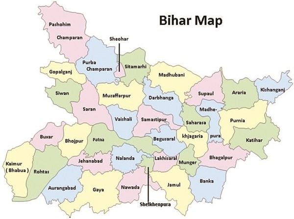
Figure 1: Map of Bihar
The global solar radiation reaching the surface of the earth divided into two components: Direct solar radiation and diffuse solar radiation.
Direct Solar Radiation: The solar radiation that reaches the Earth’s surface without being diffused is called direct or beam solar radiation. Atmospheric conditions can reduce direct beam radiation by 10% on clear, dry days and by 100% during thick, cloudy days. Direct solar radiation is measured by Pyrheliometer.
Diffuse Solar Radiation: As sunlight passes through the atmosphere, some of it is absorbed, scattered and reflected by the air molecules (Rayleigh scattering), water vapour (Mia Scattering), clouds, dust, pollutants, forest fires and volcanoes. The radiation received on the earth surface after being subjected to scattering in the atmosphere is called diffuse solar radiation. It is measured by shading pyranometer.
Global Radiation: The sum of the diffuse and beam radiation is called global solar radiation. The global solar radiation measured by pyranometer. The quantity of solar radiation reaching the Earth‘s surface at any location on any day is governed by:
- The solar elevation (at noon).
2. The duration of day.
3. The turbidity of the air.
4. The total amount of water vapour in the air.
5. The type and amount of clouds.
Of all these factors, the first two are exactly calculable and are very important; (3) and (4) cause relatively small variations in the quantity of solar radiation. But by far the largest variations are caused by clouds, particularly, the low and dense clouds. Hence, locations with the lowest cloud cover around the year offer the highest annual potential for power generation. The altitude of a place also exercises an influence on global, direct and diffuse solar radiation received at the ground.
Current Status of Solar Projects
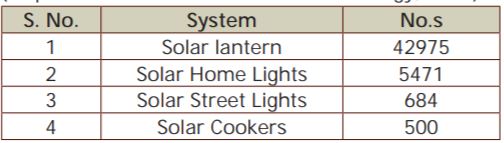
- Current status of the off-grid systems in Bihar (As per world institute of sustainable energy, Pune):
2.Current status of the grid connected power projects (As per world institute of sustainable energy, Pune):
As regards grid connected solar power projects, no solar power project is registered under Solar Mission phase I. The State Investment Promotion Board (SIPB), Bihar has approved 9 solar power projects of cumulative capacity 366 MW, comprising investment of ` 5562.72 crore.
Assessment of Available Potential
Solar radiation data from different sources
MNRE: The solar maps containing monthly and annual Direct Normal Irradiance (DNI) and Global Horizontal Irradiance (GHI) data have been developed from hourly satellite data spanning from January 2002 to December 2008. These maps cover the entire country at 10km x 10km spatial resolution. Solar resource maps and data were developed by the US National Renewable Energy Laboratory (NREL) in cooperation with India’s Ministry of New and Renewable Energy, through funding from the US Department of Energy. The data were output as data in geographic information system (GIS) format and as static maps. Solar mapping of the entire country based on satellite imagery and duly validated by ground truth data will provide information of both Direct Normal Irradiance (DNI) and Global Horizontal Irradiance (GHI) on a continuum basis with an approximate accuracy of 15%.
NASA: NASA, through its Science Mission Directorate, has long supported satellite systems and research providing data important to the study of climate and climate processes. These data include long-term estimates of meteorological quantities and surface solar energy fluxes. To foster the commercial use of the global solar and meteorological data, NASA supported, and continues to support, the development of the Surface meteorology and Solar Energy (SSE) dataset that has been formulated specifically for photovoltaic and renewable energy system design needs. In general, meteorology and solar radiation for SSE Release 6.0 were obtained from the NASA Science Mission Directorate’s satellite and reanalysis research programs. Parameters based upon the solar and/or meteorology data were derived and validated based on recommendations from partners in the energy industry.
However, the limitation of this data set is that it is only available for discrete locations and not for any specified location. Hence it can only be used for an approximate cross validation of data available from other sources.
METEONORM: METEONORM is a software program developed by METEOTEST for the calculation of solar radiation on arbitrarily orientated surfaces at any desired location. The method is based on databases and algorithms coupled according to a predetermined scheme. It commences with the user specifying a particular location for which meteorological data are required, and terminates with the delivery of data of the desired structure and in the required format. Version 6.1 is used to compute solar radiation data for different locations. METEONORM allows a user to create typical year data for any place on Earth. It provides a quick and relatively accurate overlook of weather information. However, the error in interpolating the monthly radiation values was 9%, and for temperature 1.5°C when subjected to extensive tests.
At present there are 45 radiation observatories recording various radiation parameters. At all these stations, measurement of global solar radiation is being carried out while at a few selected stations other parameters like diffuse, direct, net, net-terrestrial, reflected radiation and atmospheric turbidity are also measured. The primary objective of the observational programme is to have an understanding of basic physical processes involved in the conversion of the Sun’s radiant energy into atmospheric motions as also into chemical and biochemical energy. The observations made at national network of radiation stations are useful in the assessment of solar energy potential in different parts of the country. Data available for global and diffuse radiation is from year 1957 to 2003 and for direct radiation from 1985 to 2001. However, this data set is primarily collected for other purposes related to meteorological forecasting, agriculture, irrigation, shipping, aviation, offshore oil explorations etc and may not be adequate for basing decisions related to solar power generation. In the state of Bihar there is only one weather station at Patna for monitoring solar radiation along with other weather related physical parameters.
Radiation Analysis
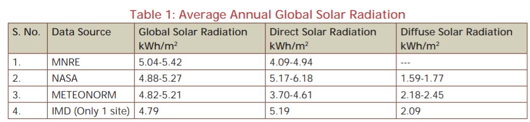
Different data sources given different range of solar radiation. Annual average solar radiation in Bihar state is given in table 1 (As per world institute of sustainable energy, Pune)
From the Table 1, we can conclude that, average annual global solar radiation comes in the range of 4.79 – 5.42 kWh/sq.m. Direct and diffuse solar radiation obtained in the range of 3.70 – 6.18 kWh/sq.m and 1.59-2.44 kWh/sq.m respectively. The MNRE solar map also shows that Bihar state, unlike North-Western parts of the country, falls in moderate solar radiation zone of India.
The availability of average annual global radiation in the state is sufficient for development of Solar PV power projects.

If you want to share thoughts or feedback then please leave a comment below.